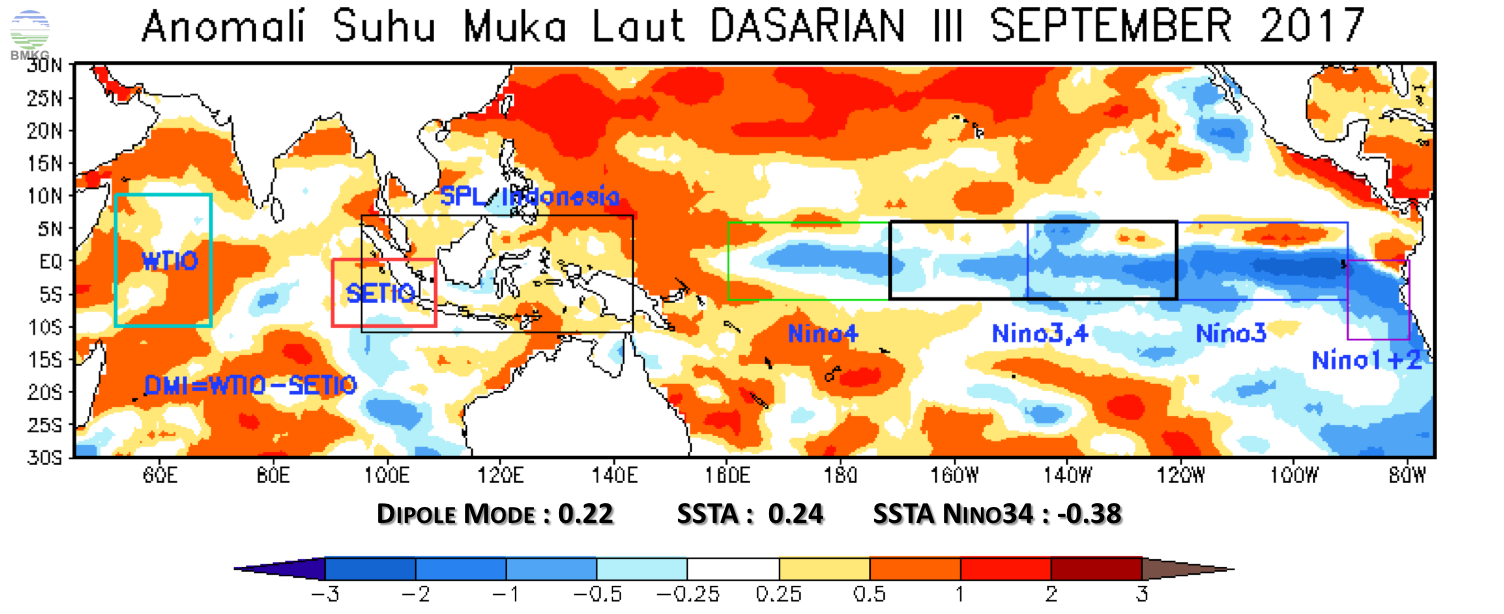
Dynamical Atmospheric and Sea Surface Temperature Analysis Decade III September, 2017
- Mohammad Ridwan
- 04 Okt 2017
ANALYSIS OF MONITORING CONSECUTIVE NO RAIN DAYS DASARIAN III SEPTEMBER 2017 (HTH> 60 Days)JAVA CENTRAL: Rembang (63), Jepara (122), EAST JAVA: Lamongan (64), Mojokerto (124), Sidoarjo (64), Pasuruan (64), Probolinggo (106), Bondowoso (110), Banyuwangi (100) , Bekasi (112), Dompuy (109), Central Lombok (83), Pamekasan (64), Sumenep (65) BALI: Buleleng (109), Klungkung (72), Karangasem (107), Bangli (81) NUSA TENGGARA BARAT: , East Sumbawa (95), Sumbawa (84) <Sumbawa Barat (84) EAST NUSA TENGGARA: Ende (96), East Flores (85), Lembata (126), East Sumba (166), Sabu Raijua (86), Rote Ndao (164), Kupang City (165), Kupang (135), South East Timor (80), Belu (86) SOUTH SULAWESI: Selayar (80), Gowa (62).
PREDICTION OCTOBER I, 2017The air mass in Indonesia is still dominated by the Wind Timuran, except in northern Sumatra and northern Borneo. There is a wind bend in the western waters of central Sumatra to East Kalimantan that support the formation of rain clouds. Based on the Asian and Autonomia Monsoon indexes indicate an increased chance of rainfall in the vicinity of western Kalimantan, central Sumatra and Java, Bali and Nusa Tenggara. Positive SST anomalies predominate in the waters of southern Sumatra and Java, the waters of Maluku and northern Papua, potentially increasing the evaporation and formation of rain clouds.
Predicted dasarian rainfall, Rainfall mostly in medium range (50 - 150 mm / Das), except in South Aceh to Bengkulu, western part of Putusibau in western Kalimantan, western part of West, Central part of West Papua, and around Jayawijaya Mountains Papua rain is still high (> 150mm / Das). Low rainfall (<50m / Das) is located around western Java (northern Cirebon), Yogya, Central Java (Pati) and most of east Java, Bali, Nusatenggara, southern South Sulawesi, southern part of Southeast Sulawesi and southern part of Papua around Meuroke.Potentially high rainfall areas of the October I watersheds: potentials around: Aceh, northern Sumatra, western Sumatra to Bengkulu, western part of Kalimantan starting western part of eastern Kalimantan, West Sulawesi and around Tolo-Toli, P. northern Seram, West Papua and around Jayawijaya Mountains to the Red Land.
Related Posts


Latest Earthquake

- 25 April 2024, 20:14:31 WIB
- 3.7
- 6 km
- 3.30 LS - 128.38 BT
- Pusat gempa berada di darat 34 km Tenggara Piru-SBB
- Felt (MMI Scale): III Kairatu
- Read More →
- Pusat gempa berada di darat 34 km Tenggara Piru-SBB
- Felt (MMI Scale): III Kairatu
- Read More →
Press Release